Changing Kakaako: Once a residential neighborhood

More than a century ago, the modern development of Kaka‘ako started as modest, wooden single-family homes. Over time, these were displaced businesses. ASD historian DeSoto Brown takes down these streets of Kaka‘ako as they looked then, and now.

DB
DeSoto Brown

September 04, 20267 min read

Ahui treet 1945
‘Āhui Street (left) seen from Queen Street (foreground) in Kaka‘ako in 1945. Wooden single family homes are interspersed with small businesses, like the barber shop on the corner on the right. (Ray Jerome Baker, Bishop Museum Archives)

Ahui and Queen Streets 2026
Āhui Street and Queen Street in Kaka‘ako in 2026. The homes are long gone, having been replaced by industrial businesses in one and two-story concrete structures, like Waialae Plumbing on the corner (which obviously is located nowhere near Waialae, despite its name.) (DeSoto Brown)

You can barely see it today, but once Kaka‘ako was largely composed of numerous individual homes. Constructed of wood starting around 1910-1915, and surrounded by yards with abundant trees, these houses were the signature of the district. Nobody was rich in Kakaako and this low-income population was, not surprisingly, prone to unsupervised children and a problem with crime. But this would start to change after the end of World War II in 1945 when the varied businesses already present would begin to gradually take over from residents as their property leases ended. Land owners sought the higher rents they could receive from commercial tenants, and Kakaako shifted mostly to this use.
Halekauwile Street
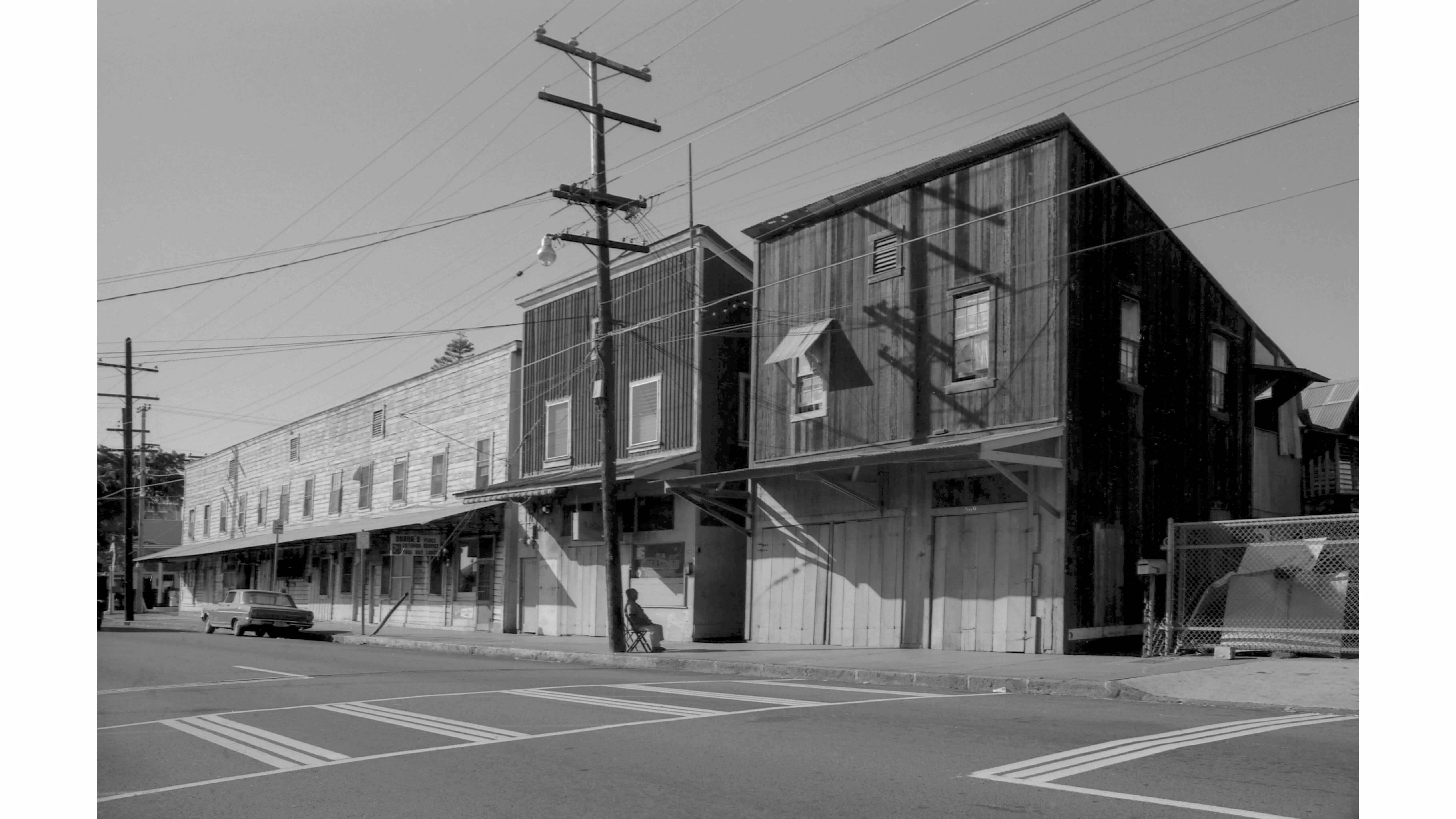
This scene is Halekauwila Street looking towards its intersection with South Street, on the far left, in 1970. Two-story wooden buildings like these were once very common in Honolulu and blocks of them lined Beretania and King Streets. Retail spaces were on the ground floor and apartments on the second, and often the owners of the former lived above their businesses. As picturesque as these may look, they were worryingly dangerous in fires. (Alan L. Brown)
Halekauwila Street  in 2026
The same scene on Halekauwila Street today is very different. The location of the wooden buildings in the previous picture would be the grassy lot next to the orange construction sign on the other side of the street, to the left. This intersection is awaiting major construction in the coming years for the Skyline and one of its stations. The latter will be situated to the left of the parking structure of the nearest large highrise. Properties on the other side of Halekauwila Street, outside of this view, have been condemned to also be cleared for this work. (DeSoto Brown)
Cummins Street in 1974
Here is Cummins Street, in the center, at its intersection with Queen Street in 1974. On the other side of the street, nestled among mature trees, is a former private home along with small business structures. Notice the lack of sidewalks or any accommodation for the drainage of rain water, typical of old Kaka‘ako. (Bishop Museum Archives)
Cummins Street in 2026
Seen from Cummins Street, there’s no hint today of old Kaka‘ako on the other side of Queen Street, as this photo shows. This is the mauka boundary of the Howard Hughes redevelopment area as the new towers clearly show. (DeSoto Brown)
Howard Hughes model Cummins Street
The large and detailed model in the Howard Hughes sales office in the IBM Building shows this same location. Cummins Street is seen here diagonally meeting Queen Street at lower right. Also visible here is the elevated track of the Skyline which someday will pass above Queen Street, which will no doubt spur even more development here when it’s completed. (DeSoto Brown)

Back when Kaka‘ako was home to thousands of people, necessary services and amenities were provided for them. Two examples of these were the Pohukaina Elementary School and its one-time playground /park, and the Kewalo Theater. The school is gone, the park remains, and the theater still exists although no films have been shown there for very close to 70 years.

Pohukaina School, 1970.
Wooden classrooms line Coral Street looking towards Pohukaina Street along the boundary of Pohukaina School in 1970. Ten years later it would be closed due to a lack of children in the neighborhood. (Alan L. Brown)
Site of former Pohukaina School in 2026
In 2026 the former Coral Street, closed in 1992, is now a green lawn that’s part of Mother Waldron Park. No trace of the former Pohukaina School still stands. (DeSoto Brown)

By 1912, enough children resided in Kaka‘ako to justify the construction of a school there, leading to the completion of a two-story concrete building for the new Pohukaina School in January 1913. Over decades, other structures also came to occupy the grounds, but as the number of students in the area dropped the Department of Education pivoted to accommodating handicapped children at the school by 1967. Eventually, these were shifted to Waialae Elementary and Kaimukī Intermediate and Pohukaina at this location closed in 1980. By January 1987 only 14 school-aged kids were determined to currently be living in Kaka‘ako.

Debates about the Pohukaina site took place after its closure. As plans for the massive redevelopment of Kakaako were projected in the 1980s and ‘90s, some argued that a new school would be needed for new residents, but not surprisingly, a highrise condo today occupies part of the property.

Mother Waldron Park, 1970
This angular wall is a distinctive part of Mother Waldron Park that’s bounded by Pohukaina Street, Cooke Street and Queen Street. This 1970 photo shows Coral Street on the right, which is no longer present here today. (Alan L. Brown)
Mother Waldron Park
A distant condo under construction contrasts with the 1937 wall in the foreground in Mother Waldron Park. This open space will fortunately remain as Kaka‘ako grows skyward in the coming years. (DeSoto Brown)

An important historic figure in Kaka‘ako’s history was Mrs. Margaret Waldron, an Irish-Hawaiian woman who labored tirelessly for decades as a social worker in what was then a notoriously tough district.

Known to all by the affectionate nickname of “Mother Waldron” she began her time in Kaka‘ako as a teacher at Pohukaina School for 18 years before becoming the Director of Recreation at a neighborhood park. Her devotion to combating gangs and crime, particularly when it touched children, and serving as a positive and helpful influence was honored in June 1930 with the naming of the Pohukaina School’s playground as Mother Waldron Park. There she continued her instructional work, speaking of how she would be teaching girls the skills of sewing and cooking in a small structure in this new park.

Her life came to an end in May 1936 but the following year, improvements and new structures in Mother Waldron Playground would be dedicated in September 1937. These cost $50,000 (or $1,162,417 in 2026 dollars) in government funding and the labor was provided through the federal government’s Works Progress Agency (WPA), an anti-Depression body that constructed innumerable public improvements all over the USA. These are still in place today; most immediately recognizable is the low zig-zag cement block wall on the ‘ewa side of the site.

In 1976 the Hawai‘i Community Redevelopment Agency was created to make over Kaka‘ako, and in 1981 its first plans for this project were presented. A foundational part of this government body’s goal was to improve the district’s infrastructure and in 1988 this led to the widening of both Pohukaina and Cooke Streets by 10 feet along with a major realignment of the latter. Along with condemnations and the clearing of former structures on its Waikīkī side, Mother Waldron Park approximately doubled in size.

The removal of Coral Street along the park’s other boundary added even more land to it in 1992. This was a wise move for the recreational needs of the increasing number of condo residents around it who would come in the future.
Kewalo Theatre brochure
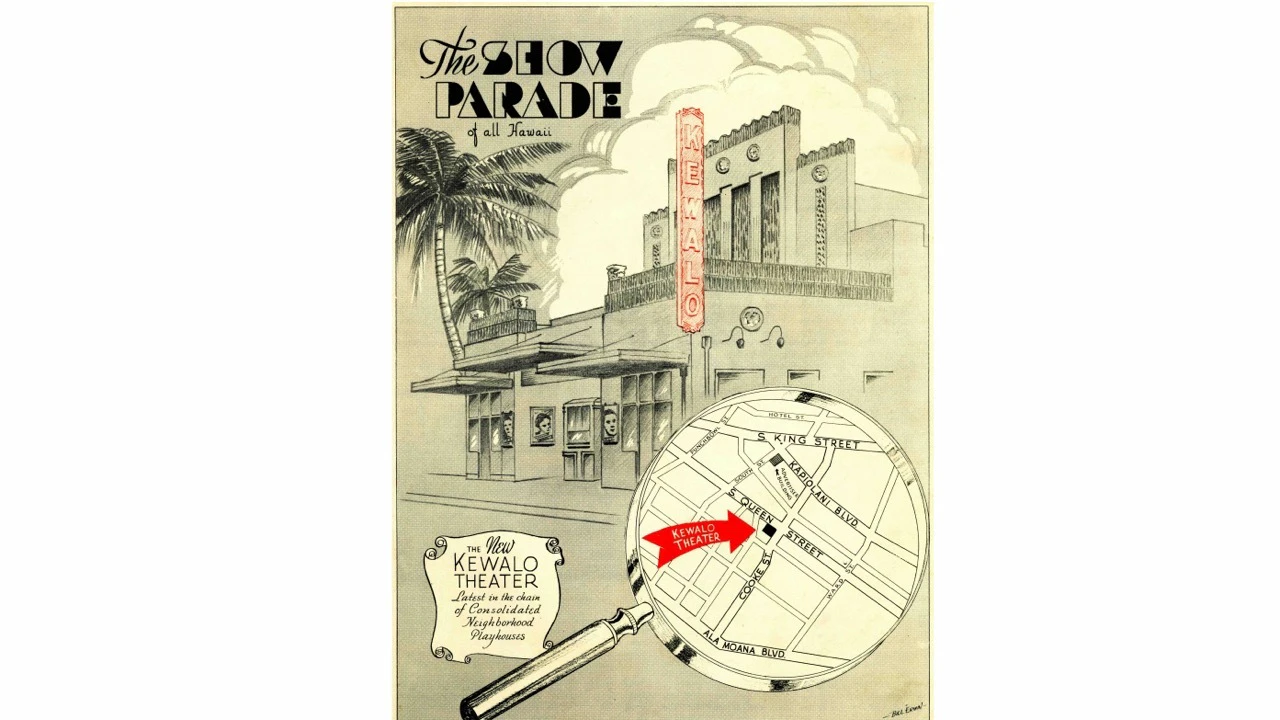
The cover of the Consolidated Amusement weekly giveaway magazine “The Show Parade of All Hawai‘i” announces the opening of the new Kewalo Theater, which took place on November 5, 1937. (DeSoto Brown Collection)
Kewalo Theater, 1970
The Kewalo Theater stayed open for only 19 years, with its last show on March 31, 1957, seven months before what would have been its 20th anniversary. In this 1970 photo it looks substantially the same as it still does today in 2026. (Alan L. Brown)

Kaka‘ako’s population in 1937 was significant enough to warrant the construction of the Kewalo Theater at the corner of Cooke and Queen Streets. Newspaper publicity for this event stated that the neighborhood was then “one of the largest and most densely populated sections in Honolulu.”

Consolidated Amusement, the biggest cinema chain in the Hawaiian Islands at that time, spent $75,000 ($1,743,626 in today's dollars) to open the latest of what it called “Neighborhood Playhouses” which served residential areas. Programs changed every day, which was true of all of Consolidated’s small theaters then, and admission was 25c for adults and only 10c for children ten years old and under.

Less than 20 years later, the Kewalo Theater was closed due to dwindling audiences as Kaka‘ako lost residents displaced by commercial tenants. Consolidated retained ownership of the empty structure for years and used it for storage, and surprisingly it still exists today. Currently occupying what had been the theater’s auditorium is the Lonohana Chocolate Company, and visitors who take a tour to see the variety of machinery which processes raw cocoa beans into tasty treats can also see remnants of the Kewalo’s 1930s interior decor still present on the walls and ceiling.

Queen Street houses 1970
Fifty-six years ago, 852 Queen Street, on the right, was a private home with a business on the street level. Island Auto Interior Service would have done reupholstering of car seats, which at that time would mostly have been vinyl fabric. Next door on the left is a single-family house with one of the large mango trees that were almost a requirement in old Honolulu neighborhoods. (Alan L. Brown)
Queen Street house, 2026
In 2026 the same view shows that, amazingly, the same house is still in place on the right with its four-car garage facing Queen Street. Until recent years this was still a car-related business; the sign that reads “KAKA‘AKO” formerly was for Kaka‘ako Auto Glass. The survival of these small miscellaneous structures in this neighborhood is, of course, uncertain in the future. (DeSoto Brown)

Kaka‘ako’s future growth will continue to displace the small industrial businesses that the area has been known for over the past decades, just as these displaced residents and private homes starting after World War II. As this process continues, we’ll see the diversity of Kaka‘ako today — as messy as it sometimes is — disappear as increasingly sterile new towers continue their takeover.

For the latest news of Hawai‘i, sign up here for our free Daily Edition newsletter.

Authors

DB

DeSoto Brown

DeSoto Brown is the historian and the curator for the Archives at Bishop Museum, where he's been employed for 40 years. In addition to working closely with the numerous treasures in Bishop Museum Archives, he's also accumulated a very large collection of Hawai‘i paper ephemera since the 1970s. DeSoto has authored a variety of books and articles for different publications; his titles include "Hawai‘i Recalls: Selling Romance to America," "Aloha Waikīkī," "Hawai‘i Goes To War: Life In Hawai‘i From Pearl Harbor to Peace," "Hawai‘i at Play: Images of a Bygone Era," "The Art of the Aloha Shirt," and "Surfing: Images From Bishop Museum Archives." He has also participated in exhibits for Bishop Museum and other institutions. He has been a regular commentator on ThinkTech Hawai‘i's online programs for 10 years, and even hosted his own radio show, "Melodies of Paradise", from 1975 to 1980.